Tanay, Province of Rizal
29 April 2017
We left Paranaque at 0630H and we were six. We traveled to Brgy. Cayabu in the province of Rizal for another trek. Everyone was excited to see Mt. Cayabu, Mt. Maynuba and at the same time, explore the series of Waterfalls of Brgy. Cayabu.
The site is approximately 55 kilometers away from our position in Paranaque and google maps approximated our travel time at 2H6Min following the suggested route and considering the traffic and other road conditions along the way.
We took Aurora Boulevard towards Marcos Highway. We passed by Sta. Lucia Grand Mall, Masinag, and Cogeo. Then after Cogeo we passed by Palo Alto and Garden Cottages. After passing KM51 post, we saw the Welcome Arch to Brgy. San Andres.
We took the road all the way to Brgy San Andres and went straight ahead. We took a rough road from Brgy. San Andres all the way to Brgy Cayabu passing through Brgy. Sto. Nino.
At the left side of the road leading to the jump-off point is Cayabu Elementary School and the Cayabu Barangay Hall.
The jump-off point is actually located at Mar-ning's Farm and Resort.
We reach the jump-off point at 0839H, registered and prepared for the whole day trek.
For the first time, we missed our breakfast because we were in a little hurry getting to the jump-off point and start the trek right away since we left Manila a little late.
At the jump-off point, we bought some supplies including our packed lunch and trail foods.
We decided to secure two guides to assist us on the trail and we were happy to meet Greg and his fellow guide. Both are from Tanay and are experienced trail guides.
At 0919H, we officially started our trek. We took the usual trail passing through the peaks first (Mt. Cayabu and Mt. Maynuba) and descend at the waterfalls.
Our guides were suggesting that we take the reverse trail instead going to the waterfalls first because of the intense heat of the sun, however, we preferred the peaks first.
Our guides were suggesting that we take the reverse trail instead going to the waterfalls first because of the intense heat of the sun, however, we preferred the peaks first.
The initial part of the trail leads to Mt. Cayabu covered with lush green vegetation similar to the trail of Mt. Makiling. Tall and green cogon grasses were all over the sides of the trail.
At 0951H, we reached an open area near the peak of Mt. Cayabu overlooking Brgy. Cayabu and the winding river below.
This is one of the best spots to witness the sea of clouds and the rising sun early in the morning.
We resumed trekking passing through the trail covered with tall and thick cogon grasses and then went through the trail portion with the bamboo trees. At 1044H, we reached the rocky and covered peak of Mt. Cayabu.
After having a quick refreshment, we resumed trekking from the peak of Mt. Cayabu towards Mt. Maynuba.
We descended on a rocky trail covered with "fresh-green" bamboo trees and later emerged on an open trail leading to Mt. Maynuba.
At 1123H, we started our ascend to Mt. Maynuba. The trail is entirely exposed. It was hot and the air was humid. According to our guides, the next shaded trail will be at the waterfalls.
We had a nice view of Mt. Cayabu along the open trail leading to the camp site near the summit. We reached the camp site at 1158H and we started to feel the sun.
The exposed camp site provides an excellent view of the surrounding green mountain slopes of the Sierra Madre mountain ranges.
Under the small trees, we had our quick lunch, had a rest and then regrouped. At 1236H, on an exposed trail under the intense heat of the sun, we resumed our adventure towards the summit of Mt. Maynuba.
The trail and summit of Mt. Maynuba can be compared to those of Mt. Talamitam and a single word can summarize all the similarities between the two mountains - "Exposed".
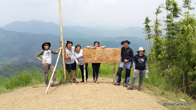
We reach the peak of the mountain at 1258H and had a quick photo-ops. We had a 20-minute rest under the bamboo trees to cool-off from the intense heat of the sun.
Slowly, we started our descent from Mt. Maynuba at 1325H heading on to the waterfalls. We reached another camp site at 1335H and stayed there shortly for another photo-ops.
From the camp site, we survived the intense heat along the exposed trail for another hour - reaching the refreshing cold water stream at 1412H.
We continued our descent on trail covered with bamboo trees towards the first water falls.
At 1426, we reached the first waterfalls and refreshed on the cool and clear water coming from the mountain.
From the first waterfalls, we resumed our descent at 1504H passing through more Rockies and several rope segments. We were like hopping from one waterfalls to the next.
According to our guides, the 8 waterfalls are actually from a single water stream coming from the mountain and then cascading on rocks forming the other waterfalls below the first waterfalls at the top.
At 1426H, we were at the second waterfalls, took a photo and then proceeded to the next and remaining waterfalls.
We reached the eighth and the last waterfalls at 1544H and then finally resumed our trek back to the jump-off point.
Our adventure was completed at 1735H.
-o0o-


