Friday, October 28, 2011

Trekking Mt. Pulag (Akiki-Ambangeg)

Province of Benguet

I was supposed to scale Mt. Kanlaon in Negros Oriental but I missed it so I decided to join Mt. Pulag hike via Akiki-Ambangeg trail.


The hike was expected to be difficult with a scale of 7 out of 9 with 9 being the hardest so I expected that there will just be a few of us.
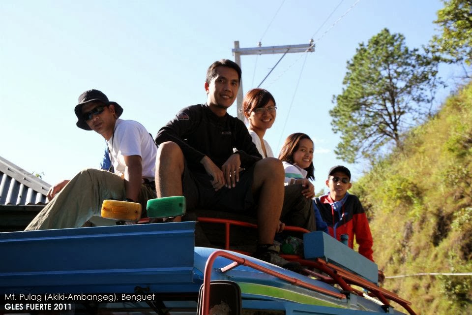
Top Load

Eight hikers met at Victory Liner Pasay terminal at 11:30PM on the 28th of October and head on to Baguio City. We reached the city of pines at about 6:30AM the following day. We had few minutes buying our supplies and then boarded a monster Jeep. We headed to the municipality of Bokod, where the DENR/Protected Area Office is located, to register.

Ambuklao Dam

Along the way, we stopped over at "Pinkan Joe" for a late breakfast and buy our packed lunch. After having our late breakfast, we decided to ride atop the monster Jeep for fun. Riding atop the monster Jeep while travelling on a zigzag road was so exciting. I enjoyed taking snap shots and video clips of nice landscapes that include the Ambuklao Dam and Power Plant.

Akiki Jump-Off Point

There are portions of the road going to Bokod that are still under construction so it was bumpy and dusty along the way.

DENR Office

We reached the DENR/Protected Area Office past 9:00AM. We registered and got some few souvenirs. From the Protected Area office, we travelled 4 hours more onboard the monster Jeep going to Akiki jump-off point. We reached the jump-off point at aroung 1:00PM.

Trail to Camp Site

It was an exciting 7 hours of travel on-board the monster Jeep from Baguio to the jump-off point. We had our lunch at the jump-off point and registered ourselves. We started trekking at about 1:30PM going to Eddet river. The trail was very nice. We reached Eddet river at about 4:00PM and set camp. The weather was also nice.


On the second day, we started preparing for a challenging climb at 3:00AM. We started trekking on the steep trail going to Marlboro Country. At this time, it started to drizzle. If the first day trek was easy, the trek going to Marlboro Country was indeed challenging. It was a very long steep trail through a forest of pine trees. We reached Marlboro Country at about 10:00AM and there was a heavy downpour. It was totally cloudy and the wind was strong. We had our early lunch and then commenced trekking to the Mossy forest at about 11:00AM.


Camp Site

We reached the Mossy forest at about 1:30PM. This forest was amazing because the trees were all covered with "moss". At the end of the Mossy forest, we reached the grassland at about 4:00PM. The golden - colored grassland was so amazing.


This part of the trek was the most challenging part. There was a heavy downpour, a strong wind and a very cold temperature. Our guide manong "Teddy" who was leading the trail had to fall back to guide the others who were at the tail of the trail. As I go further along the trail, the wind blew stronger. I can feel each drop of rain hitting my face and I had hold on my raincoat and stopped on the trail for a while to brace myself.

Trekking from Edet River

I first saw a small house, the waiting shed, near the saddle camp at the middle of the grassland and for me it was a sign of hope. As it gets colder, my hands and face turned numbed. I almost can't feel my fingers and I can't speak clearly. We were all at the saddle camp/waiting shed at about 3:30PM.

Trail to Saddle Point

Because all us were wet and shivering, Osep asked our guide if we scan stay at the waiting shed instead of pitching our tend at the saddle camp. Our guide lets us stayed at the waiting shed for a while but at the end, five of us had to be "evicted" because there were guests coming in and we can't all fit inside.

Camp Site

Gladly, after an hour, the rain subsided and five of us went back camping at the Saddle camp. We had a chance to see the sun setting at the saddle camp and it was so nice.

Sunset

Our summit assault on the following day was scheduled at 5:30AM for sunset but since there was no clearing, then we delayed it by 7:00AM.


After having breakfast, we started trekking and reached the summit at about 7:15AM. Although there was no clearing, it was still worth it to be at the summit. We started trekking to camp 2 (Ambangeg) at 7:30AM and we were there by 9:30AM. When we were at the Ambangeg trail, there was a short clearing and we saw the majestic golden landscape of Mt. Pulag.


We continued trekking to Babadak Ranger Station at 10:00AM. We were all at the Babadak Ranger station at 12:30PM, fixed ourselves and boarded the monster Jeep going to the DENR office to log-out. Along the way, we stopped over at ma'am Gina's place where we had a delicious "Pinikpikan" lunch and a coffee.

Ranger Station

We headed back to Baguio after logging-out at the DENR office. We had a flat tire along the way about 18 kilometers away from Baguio.

We were all back to Baguio at about 7:45PM and checked in at Victory bus terminal for 9:00PM scheduled trip to Manila. We decided to have a quick dinner at "Cafe by the Ruins" and then back to the bus terminal. Photos: Gallery #1 Gallery #2 Gallery #3.

-o0o-

Saturday, October 15, 2011

Trekking Mt. Arayat

Province of Pampanga
15 October 2011

Early 3:00 AM October 15, 21 hikers met at Mc Donalds El Pueblo and prepared for travel to the province of Pampanga to scale Mt. Arayat. Guiding us were Ace, Joel and Darren.

Trail leading to Mt. Arayat from jump-off point

We left Mc Donalds 4:00AM onboard two private vans. Our destination, Brgy. San Juan Baño, Arayat, Pampanga. We had a stop-over at a gas station along NLEX to buy some supplies and CR break.

We reached the DENR (Ranger Station) office at Brgy. San Juan Baño in Arayat, Pampanga 6:30AM and it was still closed. Our guide Ace had to go back to the Brgy. office to register us, get 2 local guides and settle the DENR fee for our climb.

Approaching the covered trail

We started trekking Mt. Arayat at 7:00AM. This is 1 hour and a half earlier than our IT of 8:30AM.

Mt. Arayat trail in general was nice. The first part was a nice open landscape covered mostly with cogon grass. After about an hour of trekking, we started to trek a more steep part of the mountain and this time, a forest. This part of the trail was quite tiring.

Lush green environment

Our summit assault was quite tiring because the trail going up was long compared to Pico de Loro and Sierra Madre.

At about 10:00AM, we reached the "View Deck". The view of the Pampanga river at this point was very majestic. Looking over it from the top reminded me of the arial view of Amazon River.

Mt. Arayat summit

We continued our summit and finally reached the peak-camp site 15 minutes before 12Noon.

There were about 5 mountaineers who went ahead of us and were preparing for lunch when we arrived at the summit. The summit though was covered with trees so we had to go down a little bit to have a full view of the awesome landscape below us.

Steep trail

From the summit, we saw the long and winding Pampanga river and the green rice fields some of it were still flooded. We were so lucky to be a little early at the summit. After few minutes, the clouds spread and the view was completely covered with fog.

After having few camera shots at the view deck of the summit, we went back to the camp site and had our lunch.

Huge rocks and trees along the trail

After lunch, We rested for a while and then started our descent past 1:00PM. At this time, it started to drizzle.

When we were at the middle of trail, there was a heavy down pour that made the trail slippery and muddy making our descent more challenging. Most of us were wet.

Mt. Arayat summit

Myself, Nel, Bianca and AJ went ahead and reached the jump-off point at 3:00PM. We were quite fast.

We were all back at the jump-off point safe at about 6:30PM. We finally left the DENR office at about 7:00PM and went back home to Manila straight. More photos.

-o0o-

Saturday, September 17, 2011

Trekking Tarak Ridge in Mariveles

Province of Bataan
Day 01: 17 September 2011

Probably one, if not, the most challenging major climb I ever had.

Walking to the Ranger Station

I'm proud and happy to have climbed Mt. Tarak with very good friends and of course with the legendary Sir Sky Biscocho himself.

Ranger station

While the climb was really very challenging, it was equally challenging for a novice photographer like me to take good shots of the scenes but thanks again to a heavy and nice DSLR camera, I was still able to get some nice shots even under a heavy rain.


We left Manila onboard Genesis bus at 2:00AM. We were all 15, our guides and Sir Sky Biscocho with his companion included. Everyone was so excited about the climb. We reached the jump-off point in Bataan at 5:30AM and started the trek at 6:00AM.

Steep and Slippery Trail

The first part of the trek going to Paniquian falls was quite easy. We passed through a forested area and then a beautiful landscape covered with cogon grass. When we started the trek, it was cloudy with scattered rain showers. We had a stop at the middle of trail for a rest, photo shoots and to regroup.

River Crossing

A few minutes after resuming our trek to Paniquian falls, there was a heavy down-pour and it turned foggy. This part of the trek is the longest for about 5 hours from jump-off point to Paniquian falls.

Regrouping

We reached Paniquian falls at about 10AM. Everyone was so happy to see the falls and feel the cool and clear waters. We continued trekking upstream. Crossing the stream of water flowing down from the falls under the rain, the rocks and stones were slippery making it challenging for most of us. We reached the Sllaj falls few minutes after 12PM and had relaxing lunch.

Trek to Paniquian Falls
Paniquian Falls

The trek from this point going to the camp site was the most difficult and challenging part. Climbing up a very slippery rocky steep trail carrying at least 11 kilograms of back-pack is a little scary at first.

Rope Segment
Camp Site

We reached the camp site past 4PM and the rain gets heavier and it also gets colder. Everyone was wet.After pitching our camp, we had a nice dinner and had a good night sleep. No more socials. More photos.

Day 02: 18 September 2011

We started trekking the following day at 8AM climbing up to the Japanese garden. We had a challenging steep climb once more. It was quite hard to climb on the rocky steep trail carrying a heavier wet back-pack full of wet clothes, earth pad, etc.

Japanese Garden

It was very cloudy and windy at the Japanese garden so we didn't see the nice landscape from above. We continued climbing up until we reached the Tarak peak finally.

A Favorite Photo Spot
Descending to the Ranger Station

We started our descent past 10AM, passing through a forested part of the mountain and reached Papaya River at 1PM. We stopped there for lunch. We continued our descent passing through muddy and slippery trail leading to Alasasin.

Back at the Ranger Station

We were all back to the jump-off point past 4PM. More photos.

 -o0o-

Saturday, August 27, 2011

Trekking Mt. Mayon (via Old Lava Trail)

Province of Albay
Day 01: 27 August 2011

Trekking - rain or shine!!

Jump-off point at Sto. Domingo

While most people were enjoying the safety of their home with family and loved ones and some were bracing for a category 5 typhoon Mina while it traverses from Bicol region up north to the Cagayan Valley, I was at the wilderness climbing the majestic perfect cone under unpredictable weather with four other adventurous friends at Albay.

Trail leading to Camp 1

It was a "dream-come-true" after all. It was because of my love of photography and Mt. Mayon that brought me up the mountains, meeting new friends, enjoying nature and having fun.

Volcanic Rocks and Covered Trail

Early on August 27, 2011, five climbers met at a usual meeting place in Albay - the Legazpi bus terminal. After completing the head count, we head on to the jump-off point at Sto. Domingo.

Camp 1

The jump-off point is actually a golf-course so it was nice. The first part of the climb going to camp 1, which took us about three hours, was an easy climb.

Preparing for Dinner

We passed through nice landscapes of lava trail most of which were covered with "cogon" grass already. Then we reached a forest area and then finally, camp 1.

Water Source

Super typhoon Mina was brewed somewhere near Albay so for few weeks, it was raining hard in that place. During our climb, the weather was totally cloudy and windy and drizzling. Advantage of this weather condition was that it provided a cool temperature that prevented us from getting dehydrated fast while trekking.

City of Legazpi at Night view from Camp 1

On a normal pace, we reached camp 1 just in time for lunch. There were two climbers who went ahead of us and met them at camp 1. Just after lunch, it was sleeping time. Didn't have the change to take a lot of photos because it was too foggy. There was a short clearing at night so we had a change to see Legazpi city lights from above.

Day 02: 28 August 2011

The following day, we woke up early, took some photos of sunrise, had breakfast and started the assault to the knife edge.

Early Morning Sky at Camp 1


Unlike the trail at Mt. Malinao, the trail at Mt. Mayon going up was completely different. It was made of solidified lava, large rocks and cliffs.

Trail leading to Knife-edge

Climbing this kind of wet trail was indeed very challenging. It was steep, very slippery and a little scary knowing that behind us was a cliff and at the bottom were large volcanic rocks.

Old Lava Trail Wet and Slippery

Adding up to the challenge was the fog that we had to stop for a while without moving when it turned zero visibility and we don't know whether our next step was a rock or a cliff. The cold wind travelling at about 40kph was continuously pounding us from different directions carrying rain water.

Sitting near Knife-edge

But these conditions going up the knife edge had never dampens the spirits of adventurers like us. We pushed even higher and this time, we had to remove our shoes and crawled up bare footed on the trail just to have a better grip.

View of the City of Legazpi along the old Lava Trail

After more than three hours of crawling bare footed on the slippery wet rocky trail with strong cold winds moving from different directions, we finally reached the point where we all wanted to be. At last!!

Going down the Trail barefooted

While going up was already very challenging, going down was even more challenging and took us a little longer before getting back to camp 1.

Rocky Trail

We finally left camp 1, thankful that it didn't rain while assaulting the knife edge and no accidents happened.

Sto. Domingo Golf Course Jump-off Point


An awesome, very challenging yet very nice climb at Mt. Mayon. See more photos.

Daragang Magayon!!

-o0o-