City of Jakarta, Indonesia
Day 01: Drive to North Bandung, West Java
26 October 2012
I took a late flight from Manila to Jakarta. I landed at Soekarno-Hatta International Airport nearly an hour before midnight, Jakarta time. After my emigration clearance, I finally came out of the Soekarno-Hatta International Airport Terminal at 2345H.
My friend, Rendy Sundari was waiting at the arrival area.
From Soekarno-Hatta Airport, we drove for 2 hours heading for North Bandung, West Java. North Bandung is estimated to be 70 kilometers away from Soekarno-Hatta International Airport. Few minutes before 0200H, I arrived at Hotel Bandung, a simple yet nice hotel. The place was so peaceful.
Day 02: Explore & Discover Gunung Tangkuban (Active Volcano) and Hot Springs
27 October 2012
I was so excited to start my day, specifically, to start my volcano exploration. I woke up early and had a very nice breakfast at 0700H. At 0800H, Rendy arrived at the hotel and we drove to our first destination - Explore Hot Springs at Sari Ater.
Sari Ater is at Subang, Indonesia, an hour drive away from North Bandung. We left the hotel at 0800H and drove to Subang. At 0900H, we reached Sari Ater and had a nice exploration of the hot springs. Sari Ater, after all, is a Resort.
The hot springs, according to the guides at the resort, are already part of the active volcano - Tankuban Perahu, which is about 30-minute drive away from Sari Ater.
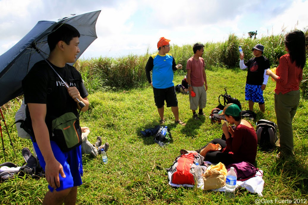
 We left Sari Ater at 1030H and drove to nearby Tangkuban Perahu. At 1100H, we reached Tangkuban Perahu National Park. There is a well maintained road going up the crater of Gunung Tangkuban and so instead of doing a short hike, we decided to just drive up to the viewing deck of the volcano main crater.
 Gunung Tangkuhan has three craters, according to our guide - Kawah Ratu (Ratu Crater) and Kawah Domas (Domas Crater) are the accessible craters. Ratu crater is the bigger crater and possibly, the main crater of the volcano. The crater diameter is slightly wider than Taal Crater. The third crater requires a day hike to reach.
 The fume of sulfur coming out from the volcano vents inside the crater was so strong. I was fascinated by the boiling mud inside the crater and the white smoke coming out from the vents. The local government installed a wooden fence for safety.
 Just because I was too eager to have a look of the whole crater, I climbed up to a higher level along the crater rim. The view of the crater was just amazing and colossal. The crater rim was full of tourist wandering at the crater of Gunung Tangkuban just like me. After few minutes, It started to rain and the clouds covered the crater almost instantly. I said, I was so lucky the crater showed up even just for few minutes and I was satisfied. A heavy downpour followed.
 From the Ratu crater, we descended a few meters and reached the entrance gate leading to the Domas crater. To see the Domas crater, we did a short trek along a well maintained trail. A local guide was assisting us.

 If I was amazed by Ratu crater, Domas crater amazed me ever more. The Domas crater consists of several smaller craters. I enjoyed so much exploring the area, looking at the active vents of yellowish-green color, a sign of sulfur coming out of the vent.


 Just like Kawah Ratu, the fume of sulfur was so strong at Kawah Domas. What made Kawah Domas more exciting than Kawah Ratu was the activities than can be done at the area - Boiling of Chicken eggs at the active vents and having a Sulfur Therapy - literally soaking your feet inside one of the hot sulfur vents and enjoy the volcanic massage.
 Around the area, there were bottles of sulfur for sale, the locals believed in the therapeutic effect of volcanic sulfur.
 Rendy bought 4 eggs and we boiled them all at the vent of Kawah Domas. I was a little reluctant to taste the boiled eggs at first because of the sulfur, but after all, I enjoyed the flavor.

 Being at Gunung Tangkuban was a great satisfaction for me. I enjoyed it so very much.
Background: Tangkuban Perahu (spelt Tangkuban Parahu in the local Sundanese dialect) is a dormant volcano 30 km north of the city of Bandung, the provincial capital of West Java, Indonesia. It last erupted in 1826, 1829, 1842, 1846, 1896, 1910, 1926, 1929, 1952, 1957, 1961, 1965, 1967, 1969, 1983. It is a popular tourist attraction where tourists can hike or ride to the edge of the crater to view the hot water springs and boiling mud up close, and buy eggs cooked on the hot surface. This stratovolcano is on the island of Java and last erupted in 1983. Together with Mount Burangrang and Bukit Tunggul, those are remnants of the ancient Mount Sunda after the plinian eruption caused the Caldera to collapse.
In April 2005 the Directorate of Volcanology and Geological Hazard Mitigation raised an alert, forbidding visitors from going up the volcano. "Sensors on the slopes of the two mountains - Anak Krakatoa on the southern tip of Sumatra Island and Tangkuban Perahu in Java - picked up an increase in volcanic activity and a build up of gases, said government volcanologist Syamsul Rizal."
ERUPTIVE HISTORY
A study conducted in 2001 determined that Tangkuban Perahu has erupted at least 30 times in the previous 40,750 years. Studies of the tephra layers within 3 km of the crater revealed that twenty one were minor eruptions and the remaining nine were major eruptions.
The eruptions that occurred prior to approximately 10,000 years ago were magmatic/phreatomagmatic. The eruptions that occurred after 10,000 years ago were phreatic." The volcano erupted as recently as February 21, 2013.
LEGEND
The name translates roughly to "upturning of (a) boat" or "upturned boat" in Sundanese, referring to the local legend of its creation. The story tells of "Dayang Sumbi", a beauty who lived in West Java. She cast away her son "Sangkuriang" for disobedience, and in her sadness was granted the power of eternal youth by the gods. After many years in exile, Sangkuriang decided to return to his home, long after the two had forgotten and failed to recognize each other. Sangkuriang fell in love with Dayang Sumbi and planned to marry her, only for Dayang Sumbi to recognize his birthmark just as he was about to go hunting. In order to prevent the marriage from taking place, Dayang Sumbi asked Sangkuriang to build a dam on the river Citarum and to build a large boat to cross the river, both before the sunrise. Sangkuriang meditated and summoned mythical ogre-like creatures -buto ijo or green giant(s)- to do his bidding. Dayang Sumbi saw that the tasks were almost completed and called on her workers to spread red silk cloths east of the city, to give the impression of impending sunrise. Sangkuriang was fooled, and upon believing that he had failed, kicked the dam and the unfinished boat, resulting in severe flooding and the creation of Tangkuban Perahu from the hull of the boat (Wikipedia).
I enjoyed Gunung Tangkuban so very much and I didn't noticed the time. We left the volcano park at 1500H. At this time, there was a heavy downpour again and the traffic was building up. Along the way, we passed by a nice green fields - tea plantations. I asked Rendy to stop for a few minutes of photo ops.
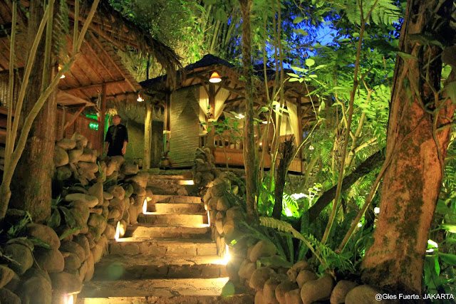 At 1800H, we reached Kampung Daun. The place called Kampung Daun is simply very nice. The place is actually at the middle of a forest with the mountain side as backdrop. I liked the setting so very much. I feel like I was at the peak of a mountain with all the trees at the side of the walk way and around the nicely built wooden villas. The warmly lighted place was simply nostalgic (Kampung Daun).
 Aside from the place, I enjoyed the local Indonesian foods. I felt like we were having a food-trip. The place was so relaxing. I was dreaming I could have a place like this in future. We had good times sharing our stories while having dinner.
 We left the place at 2000H and drove back to Jakarta. I stayed at Hotel Jakarta on my second day in Indonesia.
Day 01: Drive to North Bandung, West Java
26 October 2012
I took a late flight from Manila to Jakarta. I landed at Soekarno-Hatta International Airport nearly an hour before midnight, Jakarta time. After my emigration clearance, I finally came out of the Soekarno-Hatta International Airport Terminal at 2345H.
My friend, Rendy Sundari was waiting at the arrival area.
From Soekarno-Hatta Airport, we drove for 2 hours heading for North Bandung, West Java. North Bandung is estimated to be 70 kilometers away from Soekarno-Hatta International Airport. Few minutes before 0200H, I arrived at Hotel Bandung, a simple yet nice hotel. The place was so peaceful.
Day 02: Explore & Discover Gunung Tangkuban (Active Volcano) and Hot Springs
27 October 2012
I was so excited to start my day, specifically, to start my volcano exploration. I woke up early and had a very nice breakfast at 0700H. At 0800H, Rendy arrived at the hotel and we drove to our first destination - Explore Hot Springs at Sari Ater.
Sari Ater is at Subang, Indonesia, an hour drive away from North Bandung. We left the hotel at 0800H and drove to Subang. At 0900H, we reached Sari Ater and had a nice exploration of the hot springs. Sari Ater, after all, is a Resort.
The hot springs, according to the guides at the resort, are already part of the active volcano - Tankuban Perahu, which is about 30-minute drive away from Sari Ater.


====================
====================
Background: Tangkuban Perahu (spelt Tangkuban Parahu in the local Sundanese dialect) is a dormant volcano 30 km north of the city of Bandung, the provincial capital of West Java, Indonesia. It last erupted in 1826, 1829, 1842, 1846, 1896, 1910, 1926, 1929, 1952, 1957, 1961, 1965, 1967, 1969, 1983. It is a popular tourist attraction where tourists can hike or ride to the edge of the crater to view the hot water springs and boiling mud up close, and buy eggs cooked on the hot surface. This stratovolcano is on the island of Java and last erupted in 1983. Together with Mount Burangrang and Bukit Tunggul, those are remnants of the ancient Mount Sunda after the plinian eruption caused the Caldera to collapse.
In April 2005 the Directorate of Volcanology and Geological Hazard Mitigation raised an alert, forbidding visitors from going up the volcano. "Sensors on the slopes of the two mountains - Anak Krakatoa on the southern tip of Sumatra Island and Tangkuban Perahu in Java - picked up an increase in volcanic activity and a build up of gases, said government volcanologist Syamsul Rizal."
ERUPTIVE HISTORY
A study conducted in 2001 determined that Tangkuban Perahu has erupted at least 30 times in the previous 40,750 years. Studies of the tephra layers within 3 km of the crater revealed that twenty one were minor eruptions and the remaining nine were major eruptions.
The eruptions that occurred prior to approximately 10,000 years ago were magmatic/phreatomagmatic. The eruptions that occurred after 10,000 years ago were phreatic." The volcano erupted as recently as February 21, 2013.
LEGEND
The name translates roughly to "upturning of (a) boat" or "upturned boat" in Sundanese, referring to the local legend of its creation. The story tells of "Dayang Sumbi", a beauty who lived in West Java. She cast away her son "Sangkuriang" for disobedience, and in her sadness was granted the power of eternal youth by the gods. After many years in exile, Sangkuriang decided to return to his home, long after the two had forgotten and failed to recognize each other. Sangkuriang fell in love with Dayang Sumbi and planned to marry her, only for Dayang Sumbi to recognize his birthmark just as he was about to go hunting. In order to prevent the marriage from taking place, Dayang Sumbi asked Sangkuriang to build a dam on the river Citarum and to build a large boat to cross the river, both before the sunrise. Sangkuriang meditated and summoned mythical ogre-like creatures -buto ijo or green giant(s)- to do his bidding. Dayang Sumbi saw that the tasks were almost completed and called on her workers to spread red silk cloths east of the city, to give the impression of impending sunrise. Sangkuriang was fooled, and upon believing that he had failed, kicked the dam and the unfinished boat, resulting in severe flooding and the creation of Tangkuban Perahu from the hull of the boat (Wikipedia).
I enjoyed Gunung Tangkuban so very much and I didn't noticed the time. We left the volcano park at 1500H. At this time, there was a heavy downpour again and the traffic was building up. Along the way, we passed by a nice green fields - tea plantations. I asked Rendy to stop for a few minutes of photo ops.


====================
====================
Day 03: Explore the City of Jakarta
28 October 2012
On the last day of my visit in Indonesia, I had early breakfast and then checked-out from Hotel Jakarta. I started exploring the city at 0800H. The first place that I visited was the old Batavia City where the Museum called Fatahillah is located.


Jakarta History Museum is located in the building which was the former City Hall of Batavia, known in the past as Stadhuis. This building was the administrative headquarters of the Dutch East India Company and later of the Dutch Colonial Government. The current building was constructed in 1707 by the city government, replacing the former city hall built in 1627. Governor General Abraham van Riebeeck inaugurated it in 1710.
The building contains 37 ornate rooms. There are also some cells located beneath the front portico which were used as dungeons. A Javanese freedom fighter Prince Diponegoro, who was treacherously arrested, was imprisoned here in 1830 before being banished to Manado, North Sulawesi.
This building is located in front of a public square, which in the past was known as Stadhuisplein, the City Hall Square. The square is now known as Fatahillah Square (Indonesian: Taman Fatahillah). In the center of the square is a fountain which was used as a water supply during colonial era. Also located in the square is a Portuguese cannon (known as Si Jagur Cannon) with a hand ornament showing a fico gesture, which is believed by local people to be able to induce fertility on women. The square was also used as the place of executions.
In 1970, the Fatahillah Square was declared a Cultural Heritage. This effort was the beginning of the development of the historical area of the City of Jakarta, carried out by the Government of DKI Jakarta. The Jakarta History Museum was inaugurated on 30 March 1974 as the center for collection, conservation and research for all kinds of objects of cultural heritage related to the history of the City of Jakarta. The building's generous scale with massive timber beams and floorbands.
Jakarta History Museum has a collection of around 23,500 objects, some of them inherited from de Oude Bataviasche Museum (now the Wayang Museum). The collection includes objects from the Dutch East Indies Company, historic maps, paintings, ceramics, furnitures, and archeological objects from the prehistoric era such as ancient inscriptions and sword. The Jakarta History Museum also contains the richest collection of Betawi style furnitures from the 17th to the 19th century. The collections are divided into several rooms such as Prehistoric Jakarta Room, Tarumanegara Room, Jayakarta Room, Fatahillah Room, Sultan Agung Room, and MH Thamrin Room.
The museum also contains a replica of the Tugu Inscription from the age of Great King Purnawarman, which is the evidence that the center of the Kingdom of Tarumanegara was located around the seaport of Tanjung Priok on the coast of Jakarta. There is also a replica of the 16th century map of the Portuguese Padrao Monument, a historical evidence of the ancient Sunda Kelapa Harbor (Wikipedia).
After exploring the city of Batavia, I moved on to see Jakarta Cathedral. Something that is quite intriguing for me as I explored the Cathedral was that it stands right in front of a Mosque - Istiqlal Mosque. The people at the place said that though the Cathedral stands just in front of the Mosque, both Catholics and Muslims in Indonesia leave peacefully together.


After the arrival of Dutch East India Company in 1619, the Catholic Church was banned in the East Indies and only survived in Flores and Timor. The Netherlands was known to support Protestanism and tried to limit the influence and authority of the Holy See. During the Napoleonic Wars, the Netherlands fell under the French Empire, including its possession, the colony of Dutch East Indies. In 1806 Napoleon Bonaparte installed his Catholic younger brother Louis Napoleon (Dutch: Lodewijk) as the King of The Netherlands. Since then, the Catholic Church are free to operate in East Indies.
The Commissary General of Batavia 1825-1830 Du Bus de Gisignies was credited to provides land to build the first Catholic church in Batavia. The former residence of General de Kock in Weltevredeen area was renovated to be a church. Monseigneur Prinsen blessed and inaugurate the church in 6 November 1829 and named "Our Lady of the Assumption". In 1859 the church was renovated, however in 9 April 1890 the church collapsed.
The present church is the one rebuilt around 1891 to 1901. Pastor Antonius Dijkmans, SJ was appointed as the architect. The construction was halted because the lack of funding. The church new bishop Mgr E. S. Luypen, SJ, raised the fund in The Netherlands and the architect MJ Hulswit continued the construction in 1899. "De Kerk van Onze Lieve Vrowe ten Hemelopneming - The Church of Our Lady of the Assumption" was blessed and inaugurated by Mgr Edmundus Sybrandus Luypen, SJ in 21 April 1901. In 1988 and 2002 the church was renovated.
The plan of the cathedral took the form of a cross with a length of 60 meters and 10 meters wide, plus 5 metres on each aisle. It is a cathedral because it contains the "cathedra", the throne of bishop. The main entrance of the building is facing west. At the center of the main portal stands a statue of Our Lady Mary while on top of the portal there is a sentence written in Latin: "Beatam Me Dicentes Omnes Generationes" which means "All generations shall call me blessed". Besides, there is a large round stained glass Rozeta Rosa Mystica, which is the symbol of Mother Mary.
There are three main spires in Jakarta Cathedral: the two tallest ones measured 60 metres tall and are located in front on each side of the portal. The north tower is called "The Fort of David", which symbolizes Mary as the refuge and protector against the power of darkness. The south tower, also 60 metres tall, is called "The Ivory Tower", which the whiteness and pureness of ivory describe the pureness of Virgin Mary. On the Ivory Tower, there are old clocks that are still well functioned as well as a church bell. The third spire rises above the roof's cross intersection and measured 45 metres tall from the ground, and is called "The Angelus Dei Tower".
The building consists of two floors, the upper floor can be reached from a flight of stairs in the northern tower. Originally, the second floor used to be the place for the choir during masses, but since the cathedral is quite old, there is concern that the building cannot support the weight of too many people upstairs. Today, the upper floor functions as the Jakarta Cathedral Museum, housing the relics of Catholic rituals, such as the silver cups, hats and robes of the Dutch East Indies and Indonesian Archbishops and Cardinals. The museum also displays the history of Roman Catholicism in Indonesia.
On the southern side, there is a statue of Pietà, describing the sadness of Mother Mary while holding the body of Jesus Christ after crucifixion. The wall surrounded the interior have several scenes depicting Stations of the Cross. The cathedral has four pulpits for confession services, two on each side. At the center, there is a high raised wooden podium with shell-shaped roof for sound reflection. The podium was installed in 1905 and display the images of Hell on the lower side while the images of Jesus' sermons and other scenes are on the middle side. The top of the podium display the scene of Heaven adorned with winged angels. On the southern side, there is a large Neo-Gothic style organ made in Verschueren, Belgium, then moved and installed in Jakarta in 1988. This organ was taken from Amby village near Maastricht.
There are three altars in this cathedral: on the left side is "The Altar of Saint Mary", to celebrate the assumption of Mary to Heaven. The altar was made in 1915 by Atelier Ramakers. On the right side is "The Altar of Saint Joseph", completed in May 1922. The throne of bishop called "Cathedra" is located on the left side with three thrones. The main altar located in the center was made in 19th century in the Netherlands. It was moved from a Jesuit Church in Groningen in 1956. In this altar there is a main cross of Jesus and the tabernacle.
The body of the building was made of thick red bricks covered with plaster and applied with patterns to mimic natural stone construction. The large wall was made to support wide-spanned teak beams in the roof construction. The top of the spires was made from iron frame, while the roofs were made of teak wood construction. Actually, iron and wood are not suitable as typical Neo-Gothic architecture materials usually employ stone masonry. However these materials were chosen because they are relatively lighter than stone masonry, considering Indonesia is a region that is prone to earthquakes (Wikipedia).
From the Cathedral, I proceeded to Jakarta national Monument. This is the equivalent of Luneta or Rizal Park in Manila. I got a chance to get inside the tower basement where I saw a Diorama of Indonesian History.

Construction began in 1961 under the direction of President Sukarno. Monas was opened to the public in 1975. It is topped by a flame covered with gold foil. The monument and the museum are open daily from 08.00 - 15.00 Western Indonesia Time (UTC+7) throughout the week except for the last Monday of each month when the monument is closed.
After the Indonesian government returned to Jakarta from Yogyakarta in 1950 following the Dutch recognition of Indonesian independence, President Sukarno began to contemplate the construction of a national monument comparable to the Eiffel Tower on the square in front of the Presidential Palace. On 17 August 1954, a National Monument Committee was established and a design competition was held in 1955. This attracted 51 entries, but only one design, by Frederich Silaban, met any of the criteria determined by the committee, which included reflecting the character of Indonesia in a building capable of lasting for centuries. A repeat competition was held in 1960, but once again, none of the 136 entries met the criteria. The chairman of the jury team then asked Silaban to show his design to Sukarno. However, Sukarno did not like the design as he wanted the monument to be in the form of a linga and yoni. Silaban was asked to design such a monument, but his design was for a monument so large that it would have been unaffordable given the economic conditions at the time. Silaban refused to design a smaller monument, suggesting that construction be delayed until the Indonesian economy improved. Sukarno then asked the architect R.M. Soedarsono to continue with the design. Soedarsono incorporated the numbers 17, 8 and 45, representing the 17 August 1945 Proclamation of Indonesian Independence, in the dimensions of the monument (Wikipedia).


Background: Taman Mini Indonesia Indah (TMII) or "Beautiful Indonesia Miniature Park" (literally translated) is a culture-based recreational area located in East Jakarta, Indonesia. It has an area of about 250 acres (1.0 km2). The park is a synopsis of Indonesian culture, with virtually all aspects of daily life in Indonesia's 26 (in 1975) provinces encapsulated in separate pavilions with the collections of Indonesian architecture, clothing, dances and traditions are all depicted impeccably. Apart from that, there is a lake with a miniature of the archipelago in the middle of it, cable cars, museums, Keong Emas Imax cinema, a theater called the Theatre of My Homeland (Theater Tanah Airku) and other recreational facilities which make TMII one of the most popular tourist destinations in the city.
Since 2007 Taman Mini Indonesia Indah launched new logo with branding slogan Pesona Indonesia ("Indonesian Charm") (Wikipedia).
Before going to the airport, I had a quick view of the city. I like the architecture of the buildings - European.


In fact, Indonesia is the only country in world with the most number of known active volcanoes to date. In addition, Indonesia is the home of the world heritage sites - Borobudur and Prambanan. Things that I looked forward to explore and discover.
====================
====================
-----o0o-----